Taken at 4:25pm (approx 2 hours before "official" low tide) on 11/1/2009 atmospheric pressure was 1012 hPa
The low tides at the moment seem exceptionally low for three reasons
1. The 18.6 year maximum tide cycle (its related to the full moon)
2. High atmospheric pressure ( lowers the sea level)
3. the beach profile has change. (little of no summer berm developed and lowering of the beach generally)
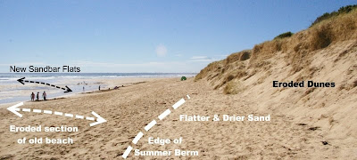
The above photo shows how different the beach profile is this year. The erosion scars at the back of the beach are "healing", the front faces have mainly collapsing and are forming a more even rill, The dry sand is being carried by the wind, eroding a smooth slope in some places and depositing and riling down in others. In front of this in only a few places a narrow summer berm is developing. This is the area mainly above high tide where the beach can dry out and wind erosion take over as the main erosion agent. The wind flattens out this zone to almost horizontal (which is why it is called a berm) When it develops a distinct bump can be seen, where the gradient of the beach changes. In previous years this summer berm may have reach 10-30m wide by mid January. Now it is only present in a few places and seldom wider than 3m. The beach in front of that still have the steep gradient more characteristic of winter and the old beach profile has been clearly lowered (much sand eroded away). In front of that there are extensive flatter areas of sandbank being developed. This sand is frequently soft (unconsolidated) because it is being moved back and forth a lot with each tide). Extensive rutting, guttering and ripple pools are being developed and then wash away in the next tide or their position and form changing daily. The beach is reaching width of 100m to 150m from dune to water edge at low tide.

